
In brief, the El Niño Southern Oscillation (ENSO) is an ordinary geological phenomenon that tends to act contrary to the prognostications of ‘experts,’ in particular the self-certified climate alarmists whose agenda is to cut carbon from our atmosphere, if fulfilled, would lead to worldwide death by starvation. Ukrainians have a term for this: Holodomor.
What is the ENSO?
“El Niño and La Niña, together called the El Niño Southern Oscillation (ENSO), are episodic departures from expected sea surface temperatures (SSTs) in the equatorial Pacific Ocean. These warmer or cooler-than-normal ocean temperatures can affect weather patterns around the world by influencing high and low-pressure systems, winds, and precipitation. ENSO may bring much-needed moisture to a region while causing extremes of too much or too little water in others.” source
Learn more about the ENSO from NOAA Physical Sciences Laboratory: El Niño Southern Oscillation (ENSO).
NOAA does not look at atmospheric CO2, or how many cows there are in the world. Atmospheric pressures at two points in the far eastern Pacific Ocean are the data used to predict El Niño/La Niña weather using the southern oscillation index.
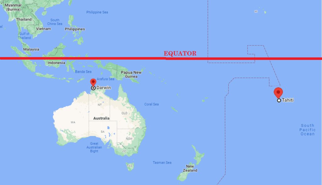
“The cyclic warming and cooling of the eastern and central Pacific can be seen in the sea level pressure in the region. For example, when the pressure measured at Darwin, Australia, is compared with that measured at Tahiti, the differences between the two can be used to generate an “index” number. A positive number indicates La Niña and a negative number indicates El Niño. Historical and recent values can be found at NOAA’s Climate Prediction Center.” source
Current Barometric Pressures at Mean Sealevel (MSP) | Current Ocean Surface Temperatures
Darwin Darwin
Tahiti Tahiti
Geology at Work
The Eurasian tectonic plate, the Indian-Australian tectonic plate, the Caroline tectonic plate, the Philippine tectonic plate, and the Pacific tectonic plate converge around Brunei and Indonesia.
The Western Pacific Warm Pool (WPMP)
“The western Pacific warm pool (WPWP) is the warmest area of the open oceans and global heat reservoir with high sea surface temperature (SST) usually warmer than 28°C accompanied by active deep convection. The temperature variation over the WPWP is closely linked with the El Niño-Southern Oscillation (ENSO), the dominant interannual climate mode in tropical Pacific. This study elucidates the above linkage from the perspective of ENSO asymmetry and diversity. Firstly, we select 12 cold and 13 warm WPWP episodes averaged from July to October. The occurrence probability of El Niño events after cold WPWP episodes is larger than that of La Niña events following warm WPWP episodes. The westerlies associated with cold WPWP episodes are much stronger and located eastwards than the easterlies for warm WPWP episodes, exerting more effective influence on the SST variation in central-eastern equatorial Pacific. On the other hand, the El Niño events tend to be stronger when the cold anomalies over WPWP are stronger. Furthermore, we highlight the implication of WPWP on El Niño flavors with a greater probability of EP-type El Niño under a colder WPWP state and successive westerly wind bursts.” source
Note: My research suggests the WPMP is not a consequence of the ENSO but its probable cause. Deep beneath those warm waters, volcanic magma, a product of plate tectonics, logically heats the Western Pacific waters. As the movement of the five convergent tectonic plates varies.
The Intertropical Convergence Zone vis-a-vis the Chemical Equator

“The Inter-Tropical Convergence Zone (ITCZ – pronounced “itch”) appears as a band of clouds consisting of showers, with occasional thunderstorms, that encircles the globe near the equator. The solid band of clouds may extend for many hundreds of miles and is sometimes broken into smaller line segments.
Its existence is due to the convergence of the trade winds: the northeast trade winds from the Northern Hemisphere and the southeast winds from the Southern Hemisphere. The point at which the trade winds meet forces the air up into the atmosphere, forming the ITCZ.” source
A boundary of air, wrapped like a belt around the earth’s equator, is keeping the polluted atmosphere of the Northern Hemisphere separate from the relatively pristine south, say UK researchers.
The team, led by Dr Jacqueline Hamilton of the University of York, have dubbed the peculiar wall of air the “chemical equator.”
And while scientists have known about the feature for decades, Hamilton’s team has just discovered an odd new wrinkle in its behavior.
Typically, where the northern and southern tropical trade winds come together they form a region of stormy updrafts called the Intertropical Convergence Zone (ITCZ).
Instead of mixing, the trade winds rise from the ocean or land surface high into the stratosphere, where they diverge again.
The circulation pattern quarantines the Northern and Southern Hemispheres, keeping the pollutant-laden northern air dirty and the southern air clean.
ABC Science: ‘Chemical equator’ keeps southern air clean
This is a work in progress. Updates are forthcoming.

John White
Rockwall, Texas
