
Learn About the ITCZ, aka the Chemical Equator
The following facts are not the opinions of the writer. These facts are documented observable phenomena. Having an understanding of the ITCZ, the ‘Chemical Equator’, is essential to understanding weather phenomena, air pollution, and dispelling pseudo-scientific myths promoted by activists on both sides of the arguments around anthropogenic influences on the earth’s atmosphere.
The object of this post is to acquaint the reader with the means by which the atmospheres of the northern and southern hemispheres do not mix. What are the implications?
Scientists have discovered a “chemical equator” that divides the polluted air of the Northern Hemisphere from the largely uncontaminated atmosphere of the Southern Hemisphere…Researchers found evidence for an atmospheric chemical line about 30 miles wide in cloudless skies in the Western Pacific, with levels of carbon monoxide four times higher on the northern side.
NBC News, Sept. 23, 2008 | Experts find ‘chemical equator’ dividing globe (ITCZ)
A boundary of air, wrapped like a belt around the earth’s equator, is keeping the polluted atmosphere of the Northern Hemisphere separate from the relatively pristine south, say UK researchers…Typically, where the northern and southern tropical trade winds come together they form a region of stormy updrafts called the Intertropical Convergence Zone (ITCZ)…Instead of mixing, the trade winds rise from the ocean or land surface high into the stratosphere, where they diverge again…The circulation pattern quarantines the Northern and Southern Hemispheres, keeping the pollutant-laden northern air dirty and the southern air clean.
ABC Science, 29 September 2008 | ‘Chemical equator’ keeps southern air clean (ITCZ)

The Northern Hemisphere tends to have more polluted air than the Southern Hemisphere because it has more cities, more population in those cities on average and more industry. And each hemisphere’s air masses tend to stay segregated from one another. That allows scientists to “see” chemical boundaries between the air masses of hemispheres by monitoring big changes in levels of air pollution…These boundaries, or chemical equators, can typically be found at a “wall” created by global air circulation patterns that separate Northern and Southern hemispheric air. Called the Intertropical Convergence Zone (ITCZ), it is a belt of low pressure that circles the Earth roughly at the equator.
LiveScience, September 30, 2008 | Earth’s Air Divided by Chemical Equator (ITCZ)
Weather on the Earth is driven by multiple factors, including thermal energy from within the Earth’s core and from the sun. Certain areas of the Earth are known for specific weather patterns that occur as a result of these factors. One area that scientists, geologists and meteorologists study frequently is the Intertropical Convergence Zone, which is a band near the equator where the southern and northern trade winds meet. Low Air Pressure In the Intertropical Convergence Zone, the northern and southern trade winds come together. Because of the rotation of the Earth, the winds cannot really cross the equator without losing energy. Instead of continuing over the Earth horizontally, the winds thus move vertically toward the upper atmosphere. The heating of the Earth’s ocean currents by the sun assists in this process, making the air warmer and letting it rise. The result is that the Intertropical Convergence Zone has low air pressure near the Earth’s surface. The lack of horizontal wind movement in the region caused sailors to nickname the Intertropical Convergence Zone, “the doldrums.
ScienceBriefss, The most important scientific discoveries of 2022 | Characteristics of the Intertropical Convergence Zone (ITCZ)
The Intertropical Convergence Zone (ITCZ), aka the Chemical Equator, works similar to an air curtain you encounter at some building entrances and exits. The most common air curtains feature a single blast of air. The video below illustrates a commercial dual air curtain that mimics the ITCZ.
Commercial air curtains, whether dual like the ITCZ or single, feature air moving downward or side-to-side. The movement of air within the global ‘air curtain’, the ITCZ, is only upward.
Airtècnics – Air Curtains, HVAC & Air Purification
The Trade Winds and the Jet Streams
Trade Winds
Between about 30 degrees north and 30 degrees south of the equator, in a region called the horse latitudes, the Earth’s rotation causes air to slant toward the equator in a southwesterly direction in the northern hemisphere and in a northwesterly direction in the southern hemisphere. This is called the Coriolis Effect.
The Coriolis Effect, in combination with an area of high pressure, causes the prevailing winds—the trade winds—to move from east to west on both sides of the equator across this 60-degree “belt.”
As the wind blows to about five degrees north and south of the equator, both air and ocean currents come to a halt in a band of hot, dry air. This 10-degree belt around Earth’s midsection is called the Inter-Tropical Convergence Zone, more commonly known as the doldrums.
U.S. Dept. of Commerce, National Ocean Service | What are the trade winds?

Jet Streams
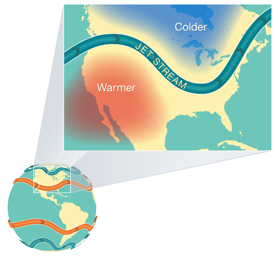
Jet streams are narrow bands of strong wind that generally blow from west to east all across the globe. Earth has four primary jet streams: two polar jet streams, near the north and south poles, and two subtropical jet streams closer to the equator. Jet streams form when warm air masses meet cold air masses in the atmosphere.
The Sun doesn’t heat the whole Earth evenly. That’s why areas near the equator are hot and areas near the poles are cold.
So when Earth’s warmer air masses meet cooler air masses, the warmer air rises up higher in the atmosphere while cooler air sinks down to replace the warm air. This movement creates an air current, or wind. A jet stream is a type of air current that forms high in the atmosphere.
On average, jet streams move at about 110 miles per hour. But dramatic temperature differences between the warm and cool air masses can cause jet streams to move at much higher speeds — 250 miles per hour or faster. Speeds this high usually happen in polar jet streams in the winter time.
Jet streams are located about five to nine miles above Earth’s surface in the mid to upper troposphere — the layer of Earth’s atmosphere where we live and breathe.
Airplanes also fly in the mid to upper troposphere. So, if an airplane flies in a powerful jet stream and they are traveling in the same direction, the airplane can get a boost. That’s why an airplane flying a route from west to east can generally make the trip faster than an airplane traveling the same route east to west.
The fast-moving air currents in a jet stream can transport weather systems across the United States, affecting temperature and precipitation. However, if a weather system is far away from a jet stream, it might stay in one place, causing heat waves or floods. More…
NOAA SkiJinks | What Is the Jet Stream?
Technical Resources
The Coriolis Effect: NOAA, NOAA SciJincks, Britannica
Atmospheric Circulation: Hadley, Ferrel, and Polar Cells
